10 Dangerous Intersections in Houston for Car Accidents
March 8, 2024
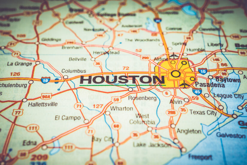
In 2023, Houston, Texas experienced 27,292 car accidents at intersections throughout the city. In this article, we’ll look at Houston’s 10 most dangerous intersections based on the number of car accidents in 2023.
This article is based on crash data in TXDOT’s CRIS system.
Here’s an overview:
- 10. Beltway 8 & Beechnut: Car Accident Danger Zone on Houston’s Outer Loop
- 9. N. Sam Houston Pkwy & JFK Blvd: A High-Risk Intersection Near Bush Airport
- 8. I-610 & N. Durham Drive: Car Accident Hotspot Near Houston’s Heights Neighborhood
- 7. US 59 (IH-69) & Hillcroft: A Busy Southwest Houston Junction
- 6. IH-45 & Rankin Road: Challenges of North Houston Traffic
- 5. I-45 & Greens Road: A Risky Intersection Near Greenspoint Mall
- 4. Beltway 8 & Alternate US 90: A Major Southwest Houston Crossroads
- 3. US 59 & Beltway 8: A High-Risk Intersection near Fondren
- 2. I-610 & N. Main Street: A Dangerous Inner Loop Intersection for Houston Drivers
- 1. Beltway 8 & Bissonnet: Houston’s Most Dangerous Intersection for Car Accidents
- How a Texas Car Accident Lawyer Can Help
10. Beltway 8 & Beechnut: Car Accident Danger Zone on Houston’s Outer Loop
In 2023, this intersection saw 55 car accidents.
This intersection sits in southwest Houston, a bustling area with a mix of residential neighborhoods, shopping centers, and businesses. Beechnut Street is a major east-west road for commuters, while Beltway 8 channels massive traffic flow around the entire city. This combination creates a constant surge of vehicles.
Here’s why this intersection is so dangerous:
- Speeding: Beltway 8 is notorious for drivers exceeding the speed limit.
- Aggressive driving: Lane changes are frequent and often abrupt, leading to sideswipes and collisions.
- Misjudgments: Drivers on Beechnut might underestimate the speed of Beltway traffic, leading to dangerous miscalculations when entering the intersection.
These factors, combined with the sheer volume of traffic, make this a high-risk area. Accidents at this intersection can be particularly severe due to the higher speeds involved on the Beltway.
9. N. Sam Houston Pkwy & JFK Blvd: A High-Risk Intersection Near Bush Airport
In 2023, this intersection saw 56 car accidents. It’s located in northeast Houston, near George Bush Intercontinental Airport (IAH).
N. Sam Houston Parkway E. (more commonly known as Beltway 8) is a massive highway loop encircling the city, while John F. Kennedy Boulevard is a major thoroughfare connecting to the airport.
Here’s what makes this intersection dangerous:
- Airport Traffic: Drivers entering and exiting the airport area add to the already heavy traffic flow on Beltway 8.
- Sudden Lane Changes: Drivers unfamiliar with the area might make sudden lane changes to reach exits or adjust their route.
- Merging Errors: Merging into high-speed traffic on the Beltway can lead to misjudgments and sideswipe collisions.
- Rear-end Accidents: Unexpected slowdowns and sudden stops are frequent due to the high volume of traffic and airport congestion. This can lead to an increased number of chain collisions and rear-end car accidents.
The combination of airport traffic and the Beltway’s inherent dangers make this intersection a consistent hazard.
8. I-610 & N. Durham Drive: Car Accident Hotspot Near Houston’s Heights Neighborhood
In 2023, this intersection recorded 56 car accidents. Located in northwest Houston, inside the 610 Loop, this intersection sits close to the popular Heights neighborhood.
IH-610 is a major inner-city freeway, and North Durham Drive is a busy multi-lane thoroughfare. Here’s why this intersection presents challenges:
- Complex Interchange: Multiple ramps, exits, and merging lanes create potential confusion for drivers unfamiliar with the area.
- High Speeds on IH-610: Accidents range from minor fender benders to catastrophic wrecks due to high speeds on the freeway.
- Distracted Driving: The combination of busy surface streets and highway traffic increases the risk of driver distraction.
- Traffic Light Mistiming: Drivers might attempt to rush through changing lights, leading to dangerous intersection crossings.
This intersection experiences a constant flow of traffic from commuters within the 610 loop and those traveling through the city on the freeway.
7. US 59 (IH-69) & Hillcroft: A Busy Southwest Houston Junction
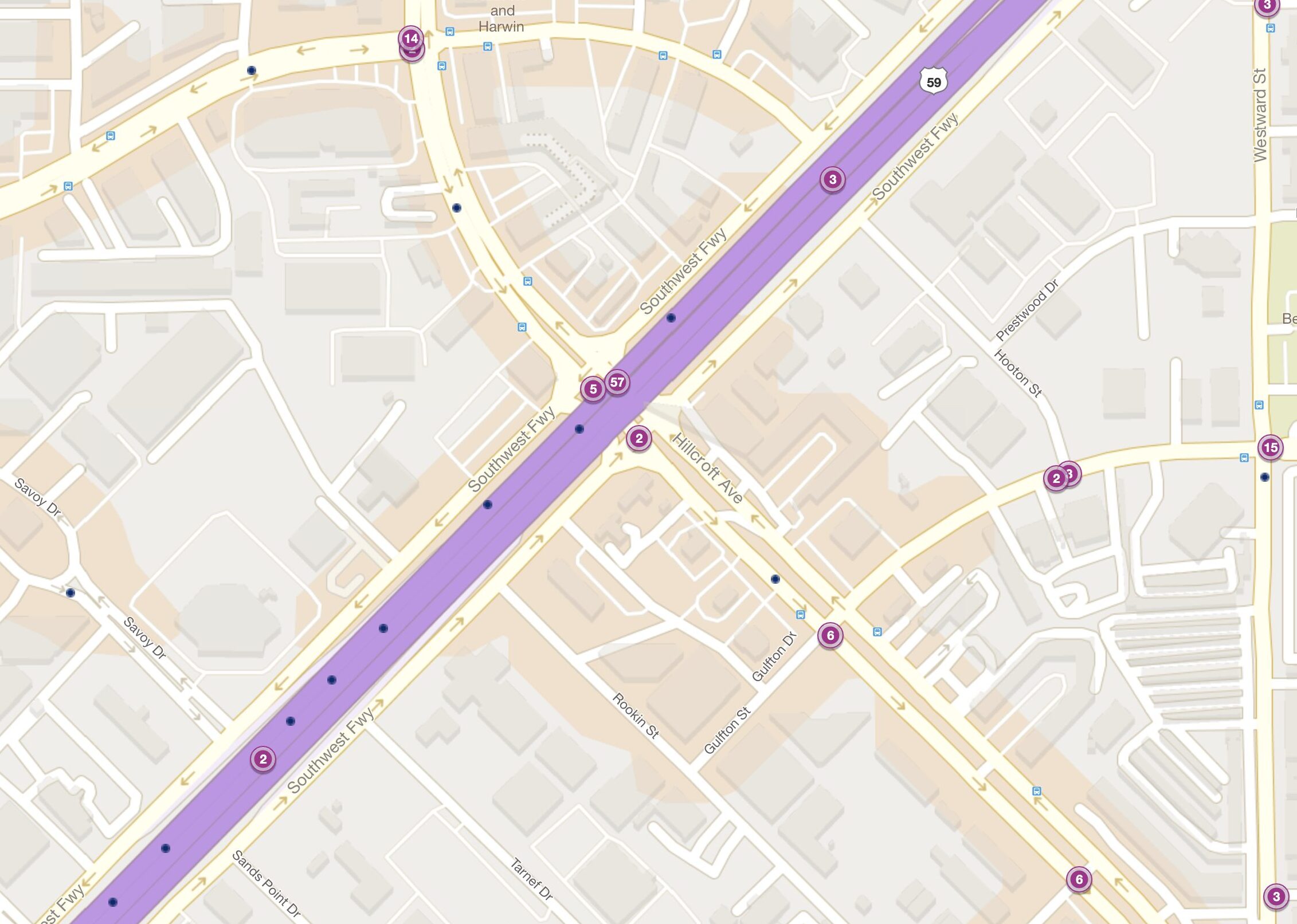
This intersection saw 57 car accidents in 2023. It’s located in southwest Houston, surrounded by bustling commercial and residential areas.
US 59 (also known as Interstate Highway 69) is a major freeway cutting through the city, while Hillcroft Avenue is a multi-lane arterial road with significant traffic flow.
What makes this intersection so hazardous:
- Distracted Driving: The busy commercial zones along Hillcroft can lead to driver distraction, causing misjudgments when entering or crossing the freeway.
- Sudden Freeway Stops: Unexpected slowdowns or stops on US 59 can lead to rear-end collisions, especially with vehicles entering from Hillcroft.
- High Traffic Volume: The sheer number of vehicles coming on and off the freeway, combined with traffic on Hillcroft, significantly increases the risk of accidents.
- Aggressive Lane Changes: Drivers on the freeway might make sudden lane changes to reach exits or adjust their routes.
The combination of freeway traffic and the surrounding commercial district make cautious driving essential at this intersection.
6. IH-45 & Rankin Road: Challenges of North Houston Traffic
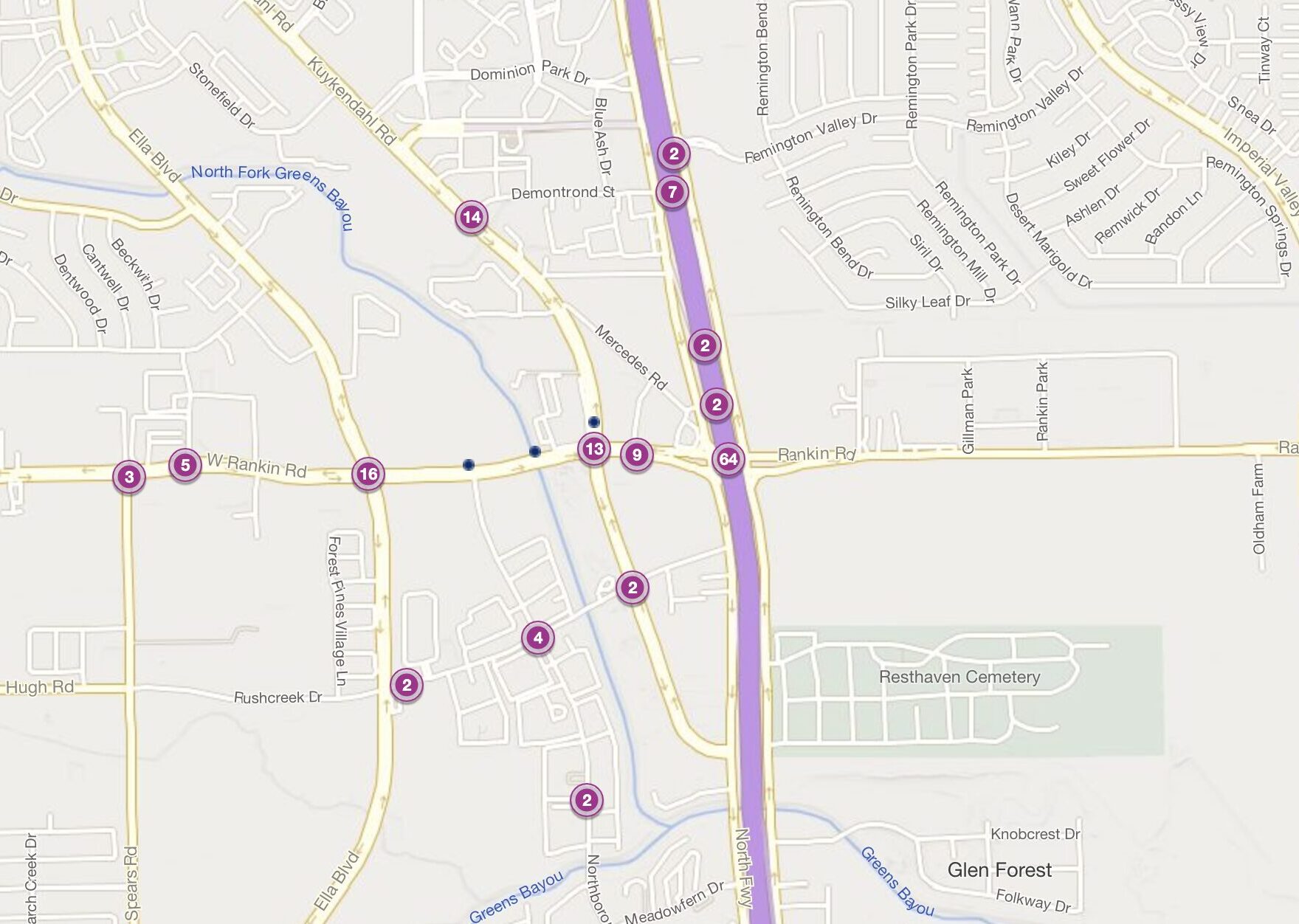
This intersection experienced 64 car accidents in 2023. Located in north Houston, this lies within a heavily trafficked area of IH-45, a major north-south freeway.
Rankin Road is a major thoroughfare with significant commercial development, leading to increased traffic entering and exiting the highway. Here’s why this intersection is risky:
- High-Speed Traffic on IH-45: Accidents often involve speeding or distracted drivers on the freeway.
- Merging Mishaps: Vehicles entering or exiting IH-45 may misjudge traffic flow or fail to yield, leading to collisions.
- Construction Zones: Construction along IH-45 can create unexpected lane changes and traffic pattern shifts, adding to the potential for accidents.
- Commercial Traffic: Delivery trucks and other commercial vehicles entering and exiting businesses near Rankin Road add to traffic congestion.
This intersection highlights the challenges of driving on a major freeway through a bustling commercial area, demanding extra vigilance from drivers.
5. I-45 & Greens Road: A Risky Intersection Near Greenspoint Mall
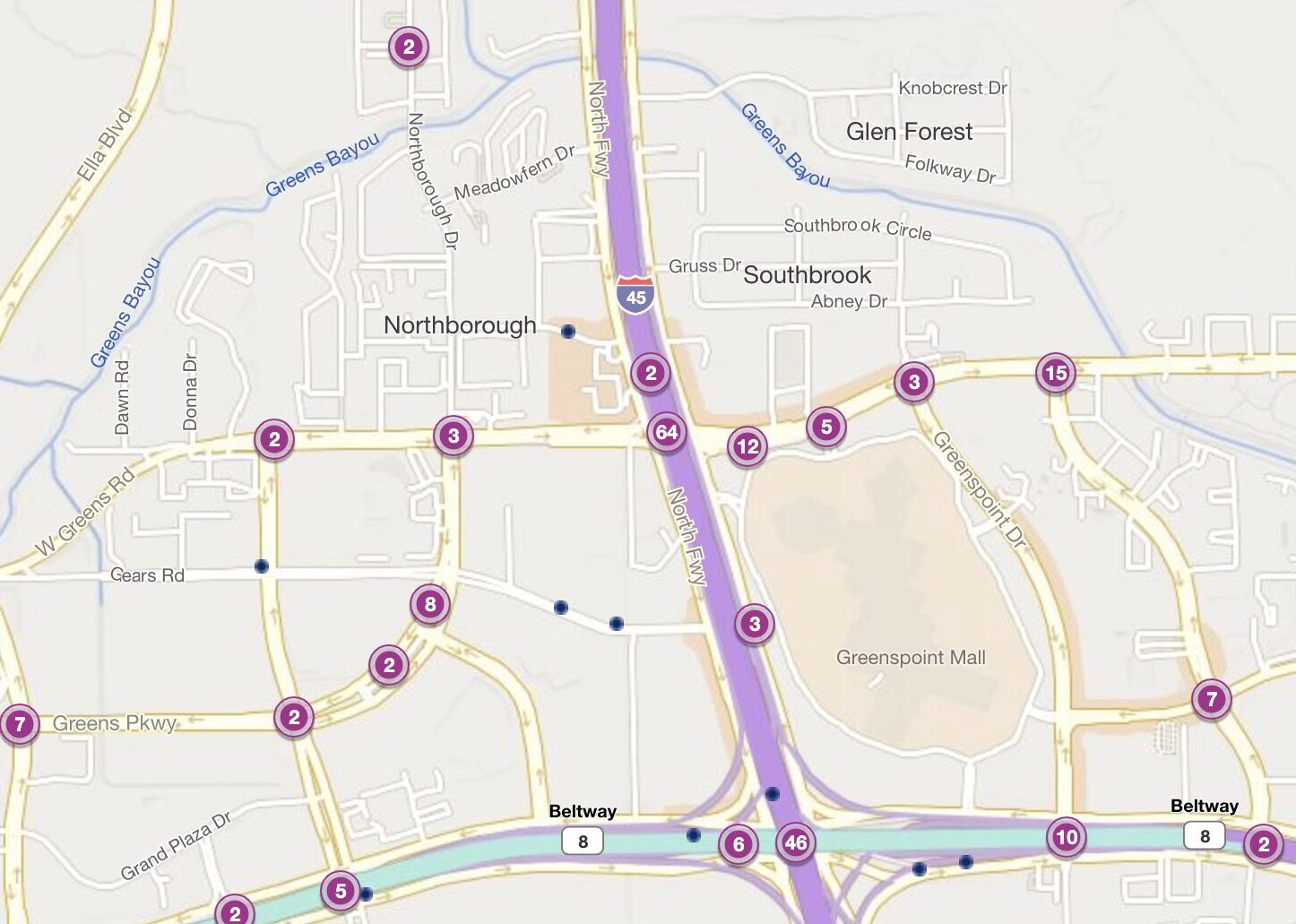
This intersection witnessed 64 car accidents in 2023.
Also located in north Houston, it provides easy access to Greenspoint Mall and other businesses in the area. IH-45 is a major freeway, while Greens Road is a busy thoroughfare feeding into it.
Factors contributing to accidents here include:
- Traffic Volume: The large amount of traffic on both IH-45 and Greens Road creates a recipe for congestion and accidents.
- Sudden Lane Changes: Drivers may make abrupt lane changes to reach exits or adjust their routes, especially during rush hour.
- Merging Errors: Vehicles entering IH-45 from Greens Road might misjudge the speed of freeway traffic or fail to yield.
- Distracted Driving: The commercial area near the intersection can lead to driver distraction, increasing the risk of misjudgments.
The intersection of IH-45 and Greens Road demands alertness from drivers due to the consistently heavy traffic flow.
4. Beltway 8 & Alternate US 90: A Major Southwest Houston Crossroads
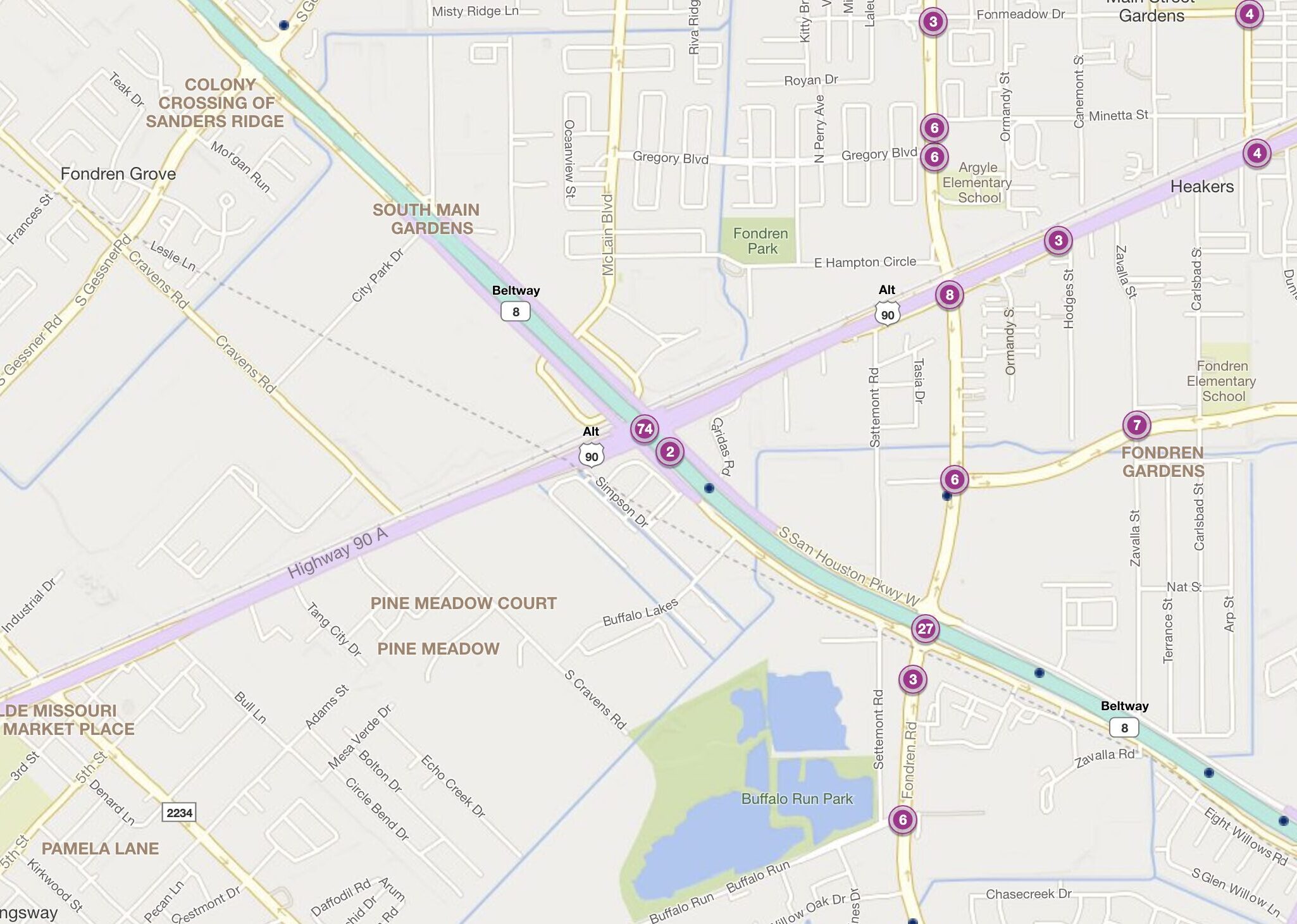
This intersection saw a concerning 74 car accidents in 2023.
Located in southwest Houston, it’s the meeting point of two major roadways: Alternate US Highway 90 and the Beltway 8 loop. Both carry a massive amount of traffic.
Here’s what makes this intersection dangerous:
- Complex Merging: The intersection’s design involves multiple lanes merging and diverging, increasing the risk of misjudgments and collisions.
- Aggressive Driving: Drivers on both roadways might exhibit aggressive behaviors like tailgating or sudden lane changes.
- High Speeds: Particularly on the Beltway, drivers tend to exceed speed limits, leading to more severe accidents.
- Limited Visibility: In some areas of the intersection, visibility can be reduced, making it harder for drivers to react in time.
The constant heavy traffic and complex layout of this intersection make it a prime spot for serious accidents, particularly sideswipes and rear-end collisions.
3. US 59 & Beltway 8: A High-Risk Intersection near Fondren
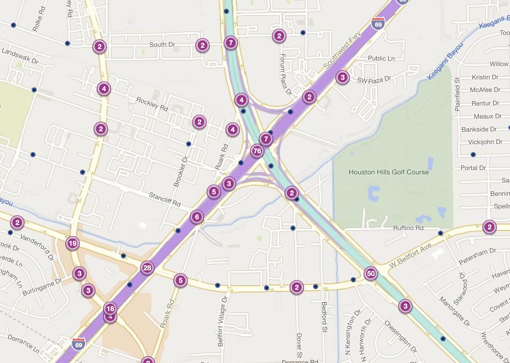
This southwest Houston intersection recorded 76 car accidents in 2023.
The intersection of US 59 (IH-69) and Beltway 8 (Sam Houston Parkway) is located near the Fondren neighborhood and sees both local commuters and long-distance travelers using these two major roads.
Here are the key dangers of this intersection:
- Extreme Traffic Volume: Both US 59 and Beltway 8 carry enormous amounts of traffic, increasing the probability of accidents exponentially.
- Merging Chaos: Drivers merging and exiting from both major roadways create a constant potential for errors.
- Aggressive Behaviors: The sheer number of cars increases the likelihood of impatient or aggressive driving, like sudden lane changes or tailgating.
- Misjudging Speed: Drivers might struggle to correctly gauge the speed of traffic, especially on the Beltway.
- Mixed Land Use and Traffic Flow: The Fondren neighborhood surrounding the intersection experiences a unique mix of traffic due to its diverse land use. Residential streets feed into the highway alongside commercial zones with delivery trucks and industrial areas with heavy machinery. This combination of vehicles traveling at high speeds alongside slower turning vehicles and pedestrians creates a complex traffic flow that can lead to accidents.
This land use map of Houston’s Fondren neighborhood highlights the mix of land uses that contributes to traffic challenges in the area:
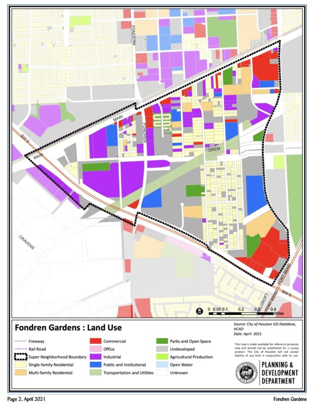
The combination of massive traffic volume and complex traffic patterns makes this a consistently high-risk area for drivers in Houston.
2. I-610 & N. Main Street: A Dangerous Inner Loop Intersection for Houston Drivers
This intersection experienced a concerning 83 car accidents in 2023.
Located inside Houston’s 610 Loop, it lies within a densely populated area with heavy commercial development. Similar to other 610 intersections, it channels a vast amount of traffic, both local and through the city.
Here’s why this intersection poses risks:
- High Traffic Volume: The sheer number of cars on both the freeway and N. Main Street creates a constant potential for congestion and collisions.
- Complex Exits & Entrances: Multiple entry and exit points on IH-610 can lead to confusion and misjudgments by drivers.
- Limited Visibility: Depending on the direction of travel, visibility at the intersection can be reduced, increasing reaction times.
- Aggressive Driving: Impatience and frustration in heavy traffic can lead to risky maneuvers, sudden lane changes, and road rage.
The complex design and constant heavy traffic of this intersection make it crucial for drivers to exercise extreme caution.
1. Beltway 8 & Bissonnet: Houston’s Most Dangerous Intersection for Car Accidents
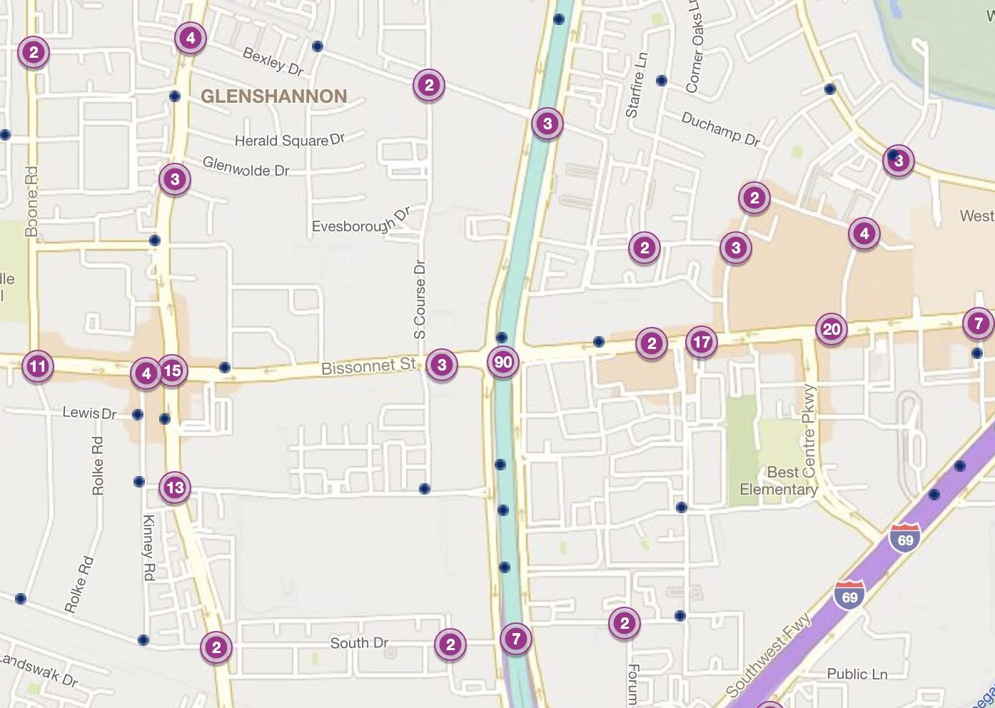
This intersection witnessed a staggering 90 car accidents in 2023.
Located in southwest Houston, this intersection marks the meeting point of Bissonnet Street, a major city thoroughfare, and the ever-busy Beltway 8. This area is a bustling commercial hub, attracting significant traffic.
Why this intersection tops the danger list:
- Extreme Speeds on Beltway 8: Vehicles on Beltway 8 routinely travel well above the speed limit, drastically increasing the severity of any potential collisions.
- Limited Visibility: In certain areas, overpasses and structures can obstruct drivers’ views.
- Aggressive Driving: The sheer volume of traffic creates frustration, leading to aggressive driving behaviors like tailgating, unsafe lane changes, and running red lights.
- Commercial Traffic: The concentration of businesses near the intersection generates additional traffic from delivery vehicles and customers.
The combination of high speeds, limited visibility, aggressive driving, and heavy commercial traffic makes this intersection the most hazardous in Houston.
How a Texas Car Accident Lawyer Can Help
If you’ve been injured in a car or truck wreck at one of these intersections or anywhere in Houston, an experienced car accident lawyer can help. A lawyer can fight for your rights and help you secure the compensation you need for your medical bills, lost wages, and pain and suffering. Don’t delay in contacting a Texas personal injury lawyer.