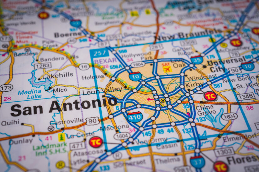
10 Dangerous Intersections in San Antonio for Car Accidents
March 10, 2024
In 2023, there were a total of 17,787 car accidents at intersections in San Antonio.
This article is based on data in TXDOT’s CRIS system.
Here’s an overview:
- 10. I-410 & Rittiman Road: Navigating Through High-Risk Traffic
- 9. I-10 & Huebner Road: A High-Risk Intersection for San Antonio Drivers
- 8. I-10 & Wurzbach Road: A Critical Junction with Elevated Accident Rates
- 7. I-410 & Marbach Road: Navigating Through High Traffic and Risks
- 6. US 90 & Loop 1604: A High-Risk Intersection Near Major Retail Centers
- 5. Loop 1604 & Culebra Road: Navigating San Antonio’s Growing Northwest
- 4. Loop 1604 & US 281 (San Pedro Avenue): A Challenging Intersection for Drivers
- 3. I-410 & US 87 (Rigsby Avenue): A Key Intersection with Elevated Risk
- 2. SH-151 & W. Military Drive: A Notorious Spot for Accidents
- 1. I-10 & Loop 1604: The Most Dangerous Intersection in San Antonio for Car Accidents
- How a Car Accident Lawyer Can Help
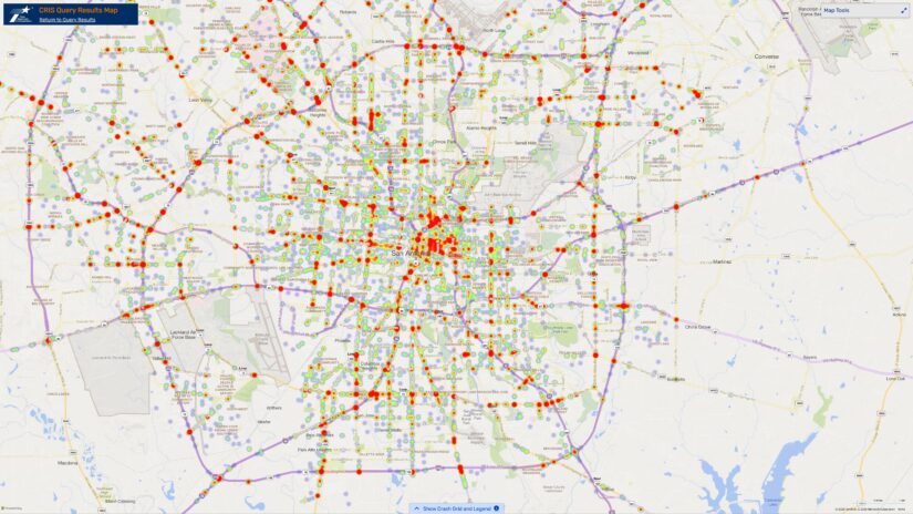
The heat map below shows the concentration of car accidents across San Antonio, Texas, in 2023. It highlights areas where drivers faced the highest risks:
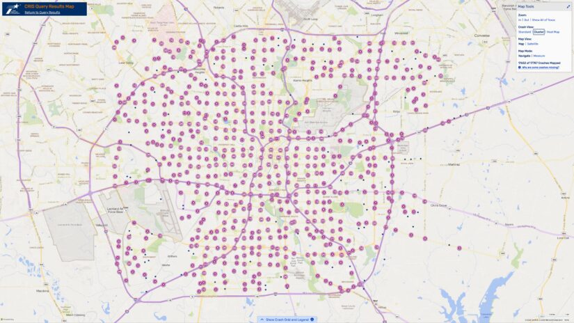
View the cluster map below to see the precise locations of intersection-related car accidents in San Antonio, Texas, during 2023, offering a clear snapshot of traffic incident hotspots:
Now let’s countdown the ten most dangerous intersections in San Antonio for car accidents based on data from the Texas Department of Transportation’s CRIS Query Tool:
10. I-410 & Rittiman Road: Navigating Through High-Risk Traffic
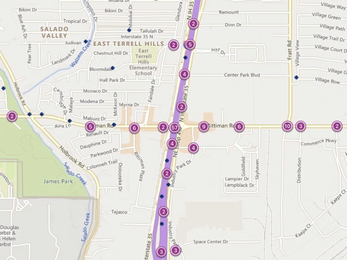
In 2023, the intersection of I-410 and Rittiman Road witnessed 57 car accidents, making it a notable risk point for drivers.
Located in the northeast part of San Antonio, this area is surrounded by commercial and military facilities, including the nearby Fort Sam Houston, contributing to its heavy traffic flow.
I-410, part of San Antonio’s loop system, facilitates travel around the city, while Rittiman Road serves as a key local thoroughfare, connecting residential areas to commercial zones and military installations.
Why It’s Risky:
- Diverse Traffic: The mix of commercial, military, and residential traffic creates complex driving conditions.
- Busy Interchange: This intersection is a busy interchange that sees a large volume of vehicles, increasing collision chances.
Common Issues:
- Frequent Lane Changes: The complexity of the interchange and the need to navigate to various exits lead to frequent and sometimes abrupt lane changes.
- Speed Discrepancies: Differences in speed between the loop and entering or exiting traffic on Rittiman Road contribute to accidents.
9. I-10 & Huebner Road: A High-Risk Intersection for San Antonio Drivers
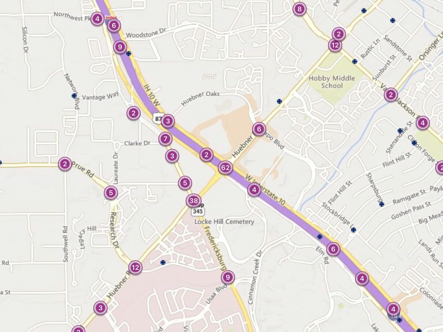
In 2023, 62 accidents were reported at the intersection of I-10 and Huebner Road.
This location sits in the northwest part of San Antonio, near the bustling Medical Center, making it a nexus of high-speed interstate and dense local traffic.
I-10 is one of the major east-west highways in Texas, and Huebner Road is a key artery serving residential and commercial areas.
Why It’s Risky:
- Diverse Traffic: The mix of fast-moving highway traffic with local road users increases collision chances.
- High Volume: The medical center attracts a lot of vehicles, adding to the congestion.
Common Issues:
- Distracted Driving: With so much around, drivers often pay less attention to the road.
- Improper Merging: Entering and exiting I-10 here is tricky and leads to many crashes.
8. I-10 & Wurzbach Road: A Critical Junction with Elevated Accident Rates
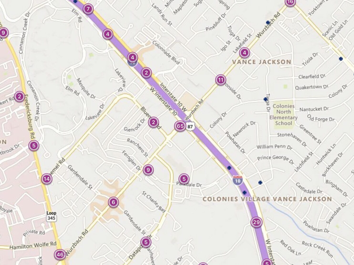
In 2023, the intersection of I-10 and Wurzbach Road experienced 65 car accidents, indicating a high level of risk for drivers.
Situated in a bustling area of San Antonio, this intersection provides critical access to residential communities, the South Texas Medical Center, and various commercial zones. I-10, a major interstate highway, facilitates east-west travel across the state, while Wurzbach Road serves as a key local thoroughfare, connecting several parts of the city with essential services and amenities.
Why It’s Risky:
- Intense Traffic Flow: Its position as a major highway interchange results in a constant stream of vehicles, heightening the chance of accidents.
- Diverse Traffic Dynamics: The combination of high-speed interstate travel with local road traffic creates complex driving conditions.
Common Issues:
- Difficult Merging: The confluence of high-speed I-10 traffic and Wurzbach Road vehicles makes merging challenging, often leading to accidents.
- Non-compliance with Signals: Frequent instances of drivers running red lights or failing to observe stop signs significantly contribute to the intersection’s accident rate.
7. I-410 & Marbach Road: Navigating Through High Traffic and Risks
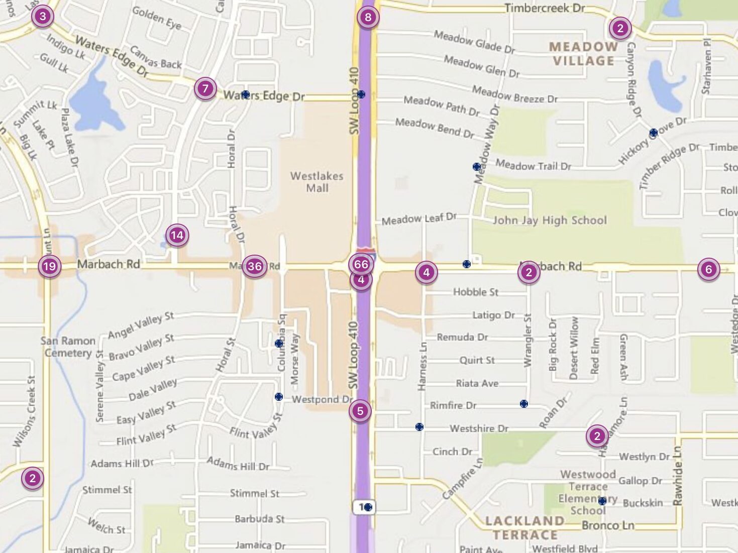
In 2023, 66 accidents occurred at the intersection of I-410 and Marbach Road.
This spot is close to numerous retail stores, lying in a densely populated area that sees a mix of local and through traffic.
The I-410 loop encircles San Antonio, providing a vital connection to various parts of the city, while Marbach Rd serves the western neighborhoods.
Why It’s Risky:
- Heavy Congestion: The area’s shopping centers and residential zones contribute to the traffic volume.
- Complex Exits: The layout of exit ramps and lanes can be confusing, especially for those unfamiliar with the area.
Common Issues:
- Aggressive Lane Changes: Drivers often switch lanes abruptly to navigate the congestion.
- Signal Ignorance: Failing to obey traffic signals is a frequent cause of collisions.
6. US 90 & Loop 1604: A High-Risk Intersection Near Major Retail Centers
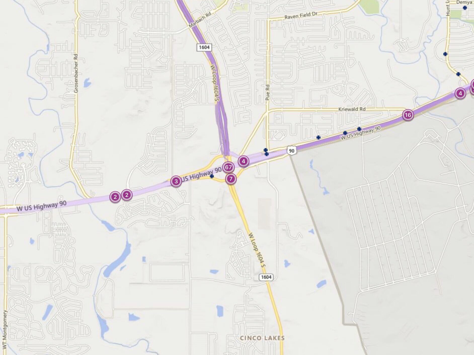
In 2023, there were 67 car accidents at the intersection of Loop 1604 and US 90.
This junction is strategically located near major shopping areas and residential neighborhoods, making it a critical point for both local and passing traffic.
Loop 1604 encircles San Antonio, offering a route around the city, while US 90 serves as a major east-west highway, connecting to downtown and beyond.
Why It’s Risky:
- High Traffic Volume: The proximity to shopping centers and residential areas significantly increases traffic.
- Mix of Traffic Types: The intersection sees a blend of high-speed highway vehicles and local traffic.
Common Issues:
- Tailgating: The high volume of vehicles leads to close following, increasing rear-end collision risks.
- Failure to Yield: Many accidents occur when drivers do not properly yield while merging or turning.
5. Loop 1604 & Culebra Road: Navigating San Antonio’s Growing Northwest
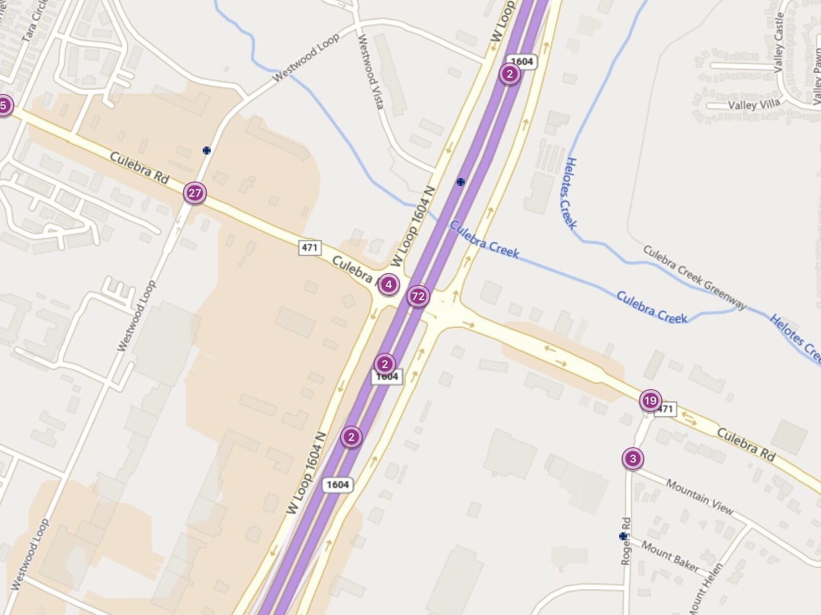
In 2023, 72 car accidents took place at the intersection of Loop 1604 and Culebra Road.
This area is near SeaWorld and several rapidly expanding residential communities, reflecting the growth in San Antonio’s northwest.
Loop 1604 serves as a key beltway around the city, while Culebra Road is an important thoroughfare for residents and visitors alike, leading to various shopping, dining, and entertainment options.
Why It’s Risky:
- Rapid Area Growth: The ongoing development in the northwest increases traffic congestion and complexity.
- Diverse Traffic: The mix of local, commuter, and tourist traffic contributes to unpredictable traffic patterns.
Common Issues:
- Ignoring Traffic Signals: Many accidents are caused by drivers running red lights or failing to stop at stop signs.
- Improper Lane Changes: The high volume of vehicles and frequent lane shifts lead to collisions.
The intersection of Loop 1604 and Culebra Road exemplifies the challenges and risks of navigating through one of San Antonio’s fastest-growing areas, underscoring the importance of vigilant and cautious driving.
4. Loop 1604 & US 281 (San Pedro Avenue): A Challenging Intersection for Drivers
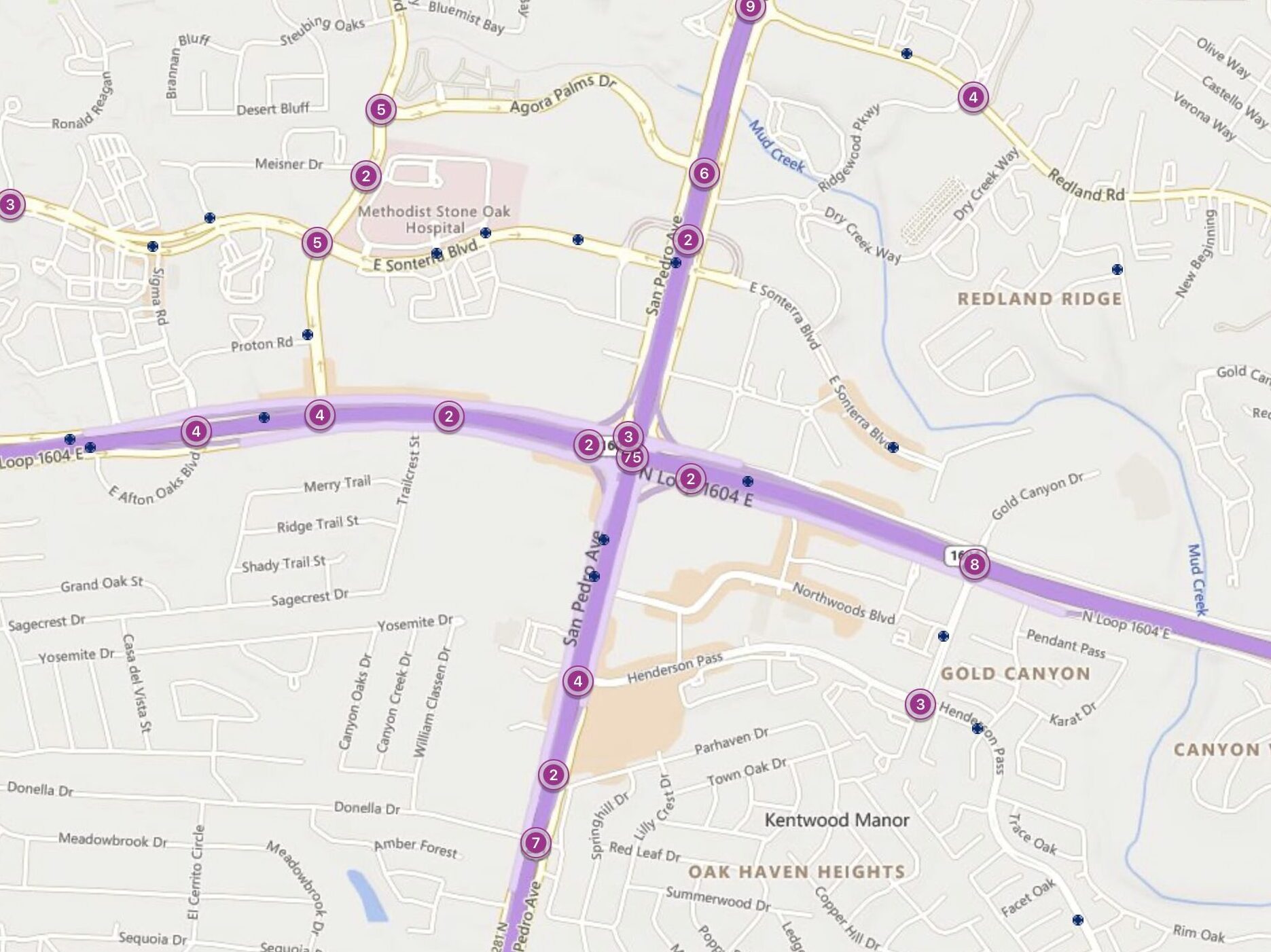
In 2023, 75 car accidents were reported at the intersection of Loop 1604 and US 281 (San Pedro Ave).
Loop 1604 provides a loop around the city, serving as a major ring road, while US 281 is a vital north-south route that cuts through the heart of San Antonio, connecting to downtown and the airport.
This key junction lies near the upscale North Star Mall, a landmark shopping destination in north-central San Antonio.
Why It’s Risky:
- High Traffic Volumes: The intersection’s proximity to major retail and commercial areas leads to dense traffic.
- Complex Interchanges: The design of this interchange, with multiple levels and lanes, complicates navigation.
Common Issues:
- Speed Variance: The difference in speeds between Loop 1604 and the ramps to and from US 281 causes accidents.
- Merging Difficulties: Drivers struggle with merging safely due to the high speeds and traffic volumes.
3. I-410 & US 87 (Rigsby Avenue): A Key Intersection with Elevated Risk
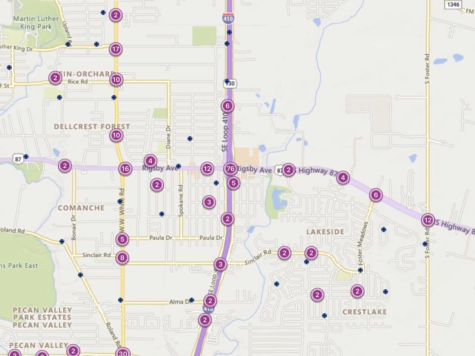
In 2023, 76 car accidents were documented at the intersection of I-410 and US 87 (Rigsby Avenue).
This area is on the southeast side of San Antonio, serving as a crucial link between the inner city and the suburban communities.
I-410, part of the city’s loop system, facilitates circular traffic around San Antonio, while US 87 (Rigsby Ave) is a significant route leading into the city’s heart, connecting residential areas with downtown.
Why It’s Risky:
- Strategic Location: Its position as a gateway to different city parts increases its traffic burden.
- Varied Traffic Flows: The intersection sees a mix of commercial, residential, and through traffic, making the flow unpredictable.
Common Issues:
- Lane Confusion: Drivers often get confused about the correct lanes for turning or continuing, leading to sudden stops or lane changes.
- Ignoring Signals: The frequency of red-light running at this intersection contributes to its high accident rate.
2. SH-151 & W. Military Drive: A Notorious Spot for Accidents
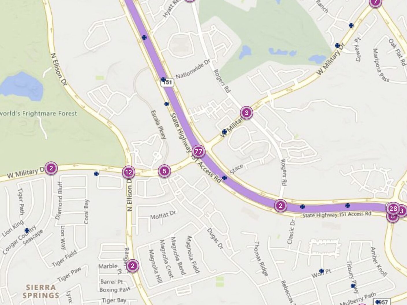
In 2023, SH-151 and W. Military Drive witnessed 77 car accidents, marking it as one of San Antonio’s most dangerous intersections.
This location is pivotal, lying west of the city center, near major attractions like SeaWorld and serving as a connector to residential and commercial areas.
SH-151 is an essential westward route from downtown, while W. Military Dr. is a key arterial road that supports a significant volume of local and through traffic.
Why It’s Risky:
- High Traffic from Attractions: The vicinity to SeaWorld and other attractions increases traffic significantly.
- Complex Intersection Layout: Multiple lanes and signal phases here can confuse drivers, especially those unfamiliar with the area.
Common Issues:
- Speeding and Aggressive Driving: The desire to beat traffic lights leads to speeding, while frustration can cause aggressive driving behaviors.
- Failure to Adhere to Signals: Accidents often occur when drivers ignore red lights or stop signs, leading to side-impact collisions.
1. I-10 & Loop 1604: The Most Dangerous Intersection in San Antonio for Car Accidents
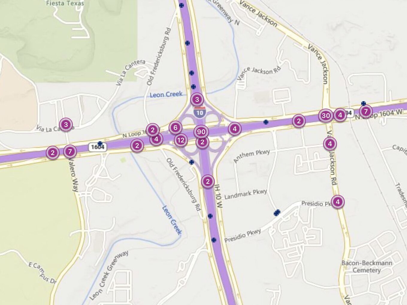
In 2023, the intersection of I-10 and Loop 1604 topped the list with 90 car accidents, making it the most dangerous intersection in San Antonio.
This critical juncture serves as a major hub for traffic in the northwestern part of the city, linking two of the most significant highways.
I-10 is a primary east-west interstate that traverses the entire country, while Loop 1604 encircles the city, acting as a key bypass and access route for suburbs and commercial areas.
Why It’s Risky:
- High Traffic Volume: The intersection accommodates a large volume of traffic, including local, commuter, and through traffic.
- Complex Design: Its design, featuring multiple lanes, ramps, and directions, complicates navigation and increases the potential for accidents.
Common Issues:
- Merging and Lane Changes: The complexity of the intersection leads to frequent issues with merging and lane changes, often resulting in collisions.
- Speed Differences: Significant speed variations between the highways and exit ramps contribute to the high accident rate.
How a Car Accident Lawyer Can Help
If you’ve been involved in an accident at one of these dangerous intersections, a car accident lawyer can provide the support and guidance you need. They can help you understand your rights and the steps to take following an accident, including:
- Navigating Insurance Claims: They can manage the often complex process of filing insurance claims to ensure you receive the compensation you’re entitled to.
- Legal Representation: If your case goes to court, they will represent your interests, advocating for fair treatment and compensation.
- Investigating the Accident: Your lawyer can gather evidence, such as traffic camera footage and witness statements, to build a strong case on your behalf.
- Evaluating Compensation: They can accurately assess the full extent of your damages, including medical expenses, lost wages, and pain and suffering, to ensure your settlement covers all your needs.
An experienced car accident attorney or truck accident lawyer can be an invaluable asset in helping you recover from an accident, allowing you to focus on your recovery while they handle the legal details.